

I’m based in County Durham, so mining legacy comes up a lot. Most of the deep pits closed decades ago, and the ground they left behind usually looks like any other field, playing field or housing estate. You’d never know it was there.
It’s one of the best-recorded ground risks we have, and it still catches developers out. That’s rarely because the information wasn’t available. It’s usually because nobody looked until the site had already been bought, or until the planning officer asked for something.
You often can’t see it
A shaft that was capped a hundred years ago can sit under topsoil and grass with nothing at the surface to show for it. Shallow workings are the other one. Coal was taken out close to the surface long before anyone had to draw a plan of it, and the voids left behind can work their way upwards years later. You won’t find either on a walkover, and you certainly won’t spot them driving past.
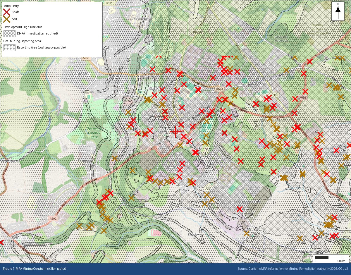
Our Consett sample report is a good example. It’s one of the free samples on geoscreen.uk. The site is inside a Mining Remediation Authority Development High Risk Area. There are 40 recorded mine entries within a kilometre, seven within 500 metres, and the nearest is a shaft about 170 metres to the north-east. Stand on the site and you’d see none of that, but it’s all in public records.
The records aren’t complete
For a long time nobody had to record where mine workings went. Plans of abandoned mines only had to be deposited from the 1870s, and a lot of early shallow working was never drawn at all. So the public record is the best picture we have, but it isn’t the whole picture.
That works both ways. A recorded shaft near your site is real information. But if you’re in an area with a long history of mining and nothing is recorded nearby, that doesn’t mean there’s nothing there. It might just mean nobody wrote it down. This is why the Development High Risk Area matters. It’s where the Mining Remediation Authority thinks shallow mining is likely to be an issue for new development, whether or not every shaft and working has been plotted.
It tends to turn up late
This is where it gets expensive. For most development in a Development High Risk Area, the local planning authority will want a Coal Mining Risk Assessment as part of the planning process. You can buy one from the Mining Remediation Authority, who have their own team that prepares them, or get a suitably qualified consultant to do one using the Authority’s data. If it says the shallow workings or shafts need investigating, you’re looking at drilling, and maybe grouting or changes to the foundations, before you build anything.
None of that is unusual, and it isn’t a reason to walk away from a site. The problem is finding out after you’ve agreed a price, because then the cost comes out of your margin and not the seller’s.
Which search do you need?
These get mixed up a lot, so quickly.
A CON29M is the standard coal mining search that conveyancers order. It’s cheap, and it tells you whether the property is in a coal mining area and what’s recorded.
The Mining Remediation Authority’s Consultants Coal Mining Report goes further. It’s aimed at the engineers and consultants working on the site.
A Coal Mining Risk Assessment is the planning document. It takes all of that and looks at what it means for your specific development. If you buy it from the Mining Remediation Authority, their Consultants Report comes included.
What I’d do is find out early whether the site is in a coal mining reporting area or a Development High Risk Area at all, and then order the searches that fit. That first step is what a GeoScreen report does in a couple of minutes. It checks both designations, lists the recorded mine entries around the site and where they are, and says which of those searches is worth getting.
It’s not just coal
Coal gets most of the attention, and there are good reasons for that. It was historically the biggest mining industry in the UK by a long way, and it’s also the best recorded. The Mining Remediation Authority keeps a national archive of coal mine plans and recorded mine entries, and nothing quite like it exists for other minerals. But plenty of other things were mined too. Metal ores, ironstone, limestone, gypsum, salt and chalk were all worked in different parts of the country, some of it very shallow, and the records for those are more scattered. The British Geological Survey maps the potential for non-coal mining separately, and it’s worth checking even if your site is nowhere near a coal seam.
If you’re looking at land anywhere with an industrial past, it’s worth checking before the price is agreed rather than after.
