

If you’re buying land or bringing a site forward for development in England, flood risk is one of the first things a planning authority will look at — and one of the most common reasons a scheme runs into difficulty. Yet the flood zone system is widely misunderstood, and a surprising number of site appraisals treat a flood zone as a simple pass or fail. It isn’t.
Here’s what the flood zones actually mean, what they don’t tell you, and when you’ll need to do more.
What the flood zones are
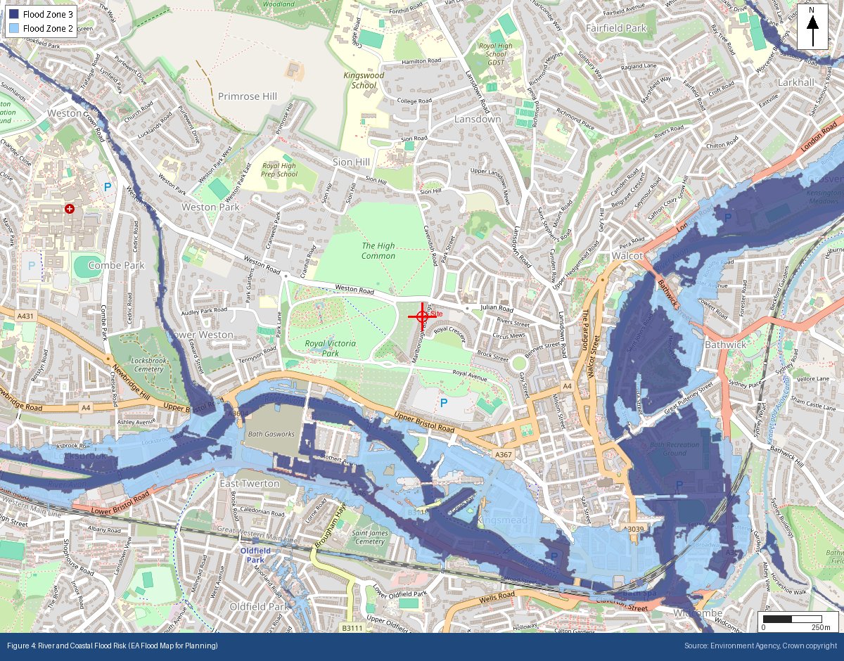
The Environment Agency publishes the Flood Map for Planning, which divides England into flood zones according to the probability of flooding from rivers and the sea. There are effectively four:
Flood Zone 1 (low probability) — land with less than a 0.1% chance of river or sea flooding in any given year (less than 1 in 1,000). Most of England falls into Zone 1, and most development is acceptable here on flood-risk grounds.
Flood Zone 2 (medium probability) — land between a 0.1% and 1% annual chance of river flooding (1 in 1,000 to 1 in 100), or between 0.1% and 0.5% for the sea (1 in 1,000 to 1 in 200).
Flood Zone 3a (high probability) — land with a 1% or greater annual chance of river flooding (1 in 100 or higher), or 0.5% or greater from the sea (1 in 200 or higher).
Flood Zone 3b (the functional floodplain) — land where water actually flows or is stored during a flood. Development here is heavily restricted. Importantly, Zone 3b is often not shown on the standard Flood Map for Planning — it’s usually defined through a local authority’s Strategic Flood Risk Assessment or by site-specific hydraulic modelling. So a site can sit in “Zone 3” on the public map and only later be found to include functional floodplain.
The critical nuance most people miss
The flood zones ignore existing flood defences. The mapping shows the probability of flooding as if the flood banks, walls and barriers weren’t there. That’s deliberate — defences can fail or be overtopped, and planning policy requires the residual risk to be considered. So a site sitting behind a substantial flood wall will still carry the flood zone designation of the undefended land. It doesn’t mean the defence is ignored in practice; it means the underlying risk has to be understood before you rely on that protection.
It’s also why a public flood risk checker can appear to contradict a planning flood zone: the consumer-facing tools generally show risk with defences taken into account, while the planning maps deliberately don’t. Both are right; they answer different questions. GeoScreen reports show the defended view as a separate reference figure alongside the statutory zones, so the difference is visible rather than confusing — but every flood rating is based on the statutory undefended mapping, as planning policy requires.
The zone is only half the picture
A common mistake is to assume the flood zone alone decides what you can build. It doesn’t. Planning policy pairs the flood zone with the flood risk vulnerability classification — a system that sorts development types into five categories, from water-compatible uses through to highly vulnerable development and essential infrastructure. It’s the combination of flood zone and vulnerability that determines whether a use is acceptable, and whether the planning tests apply.
Those tests are the Sequential Test — which steers development toward areas of lowest flood risk, and asks whether there are reasonably available sites at lower risk — and, where that can’t be satisfied, the Exception Test, which requires the development to deliver wider sustainability benefits and to be demonstrably safe for its lifetime without increasing flood risk elsewhere.
When you’ll need a Flood Risk Assessment
Under the NPPF, a site-specific Flood Risk Assessment is required for all development in Flood Zones 2 and 3. It’s also required in Flood Zone 1 where the site is one hectare or larger, where the Environment Agency has identified critical drainage problems, where a Strategic Flood Risk Assessment flags increased future risk, or where the proposal would introduce a more vulnerable use. In other words, “Zone 1” doesn’t automatically mean “no assessment needed.”
Flood zones don’t cover surface water
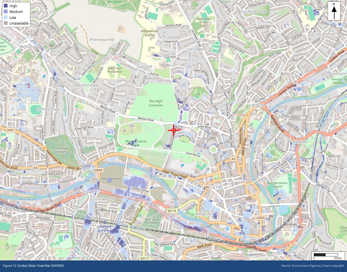
One of the most important limitations: the Flood Map for Planning covers flooding from rivers and the sea only. It says nothing about surface water (pluvial) flooding — water pooling and flowing across the ground during heavy rainfall — which is assessed on an entirely separate Environment Agency map. Plenty of sites sit comfortably in Flood Zone 1 for river and sea flooding while carrying significant surface water flood risk. Treating a Zone 1 designation as “no flood risk” is one of the more common and costly appraisal errors.
What’s changed recently
In 2025 the Environment Agency updated the Flood Map for Planning to draw on its new national flood risk model (NaFRA2), bringing more consistent modelling and updated climate-change allowances into the picture. The flood zone definitions themselves are unchanged, and the Agency remains a statutory consultee on planning applications — but the underlying data is now more detailed, and future flood risk is more explicitly represented. It’s worth checking that any appraisal you’re relying on reflects the current mapping rather than an older extract.
What about Wales?
Wales runs a parallel system. Natural Resources Wales publishes its own Flood Map for Planning, using the same Zone 2 and Zone 3 structure and the same undefended principle, with the planning tests set out in Technical Advice Note 15 rather than the NPPF. NRW also publishes a separate defended risk assessment — which is what its public flood risk checker shows, and why that tool can give a lower answer than the planning map for the same site.
Where GeoScreen fits
A GeoScreen report identifies the Flood Zone for any site in England or Wales automatically, drawing directly from the Environment Agency’s or Natural Resources Wales’s Flood Map for Planning, and assesses river/coastal and surface water flood risk separately — so a Zone 1 site with a surface water problem doesn’t slip through. It’s the fast way to establish the flood risk picture at the point it matters most: before you commit to a site.
What it doesn’t do — and doesn’t claim to — is replace a site-specific Flood Risk Assessment where one is required. It tells you where the risk lies, what kind of assessment the site is likely to need, and whether flood risk should be shaping your decision before you go further. For development in Flood Zones 2 or 3, or the larger Zone 1 sites, a professional FRA remains essential — and every GeoScreen report says so.
Tristan Morgan BSc(Hons) EurGeol CGeol FGS AMICE is a UK Registered Ground Engineering Specialist and Director of Magnum GSI Ltd. GeoScreen® is an automated geotechnical ground risk screening platform available at geoscreen.uk.
Screen your site’s flood risk with GeoScreen at geoscreen.uk
