 ASSETS_(Mar 21)")

GeoScreen — an automated geotechnical desk study platform — is now live in two tiers:
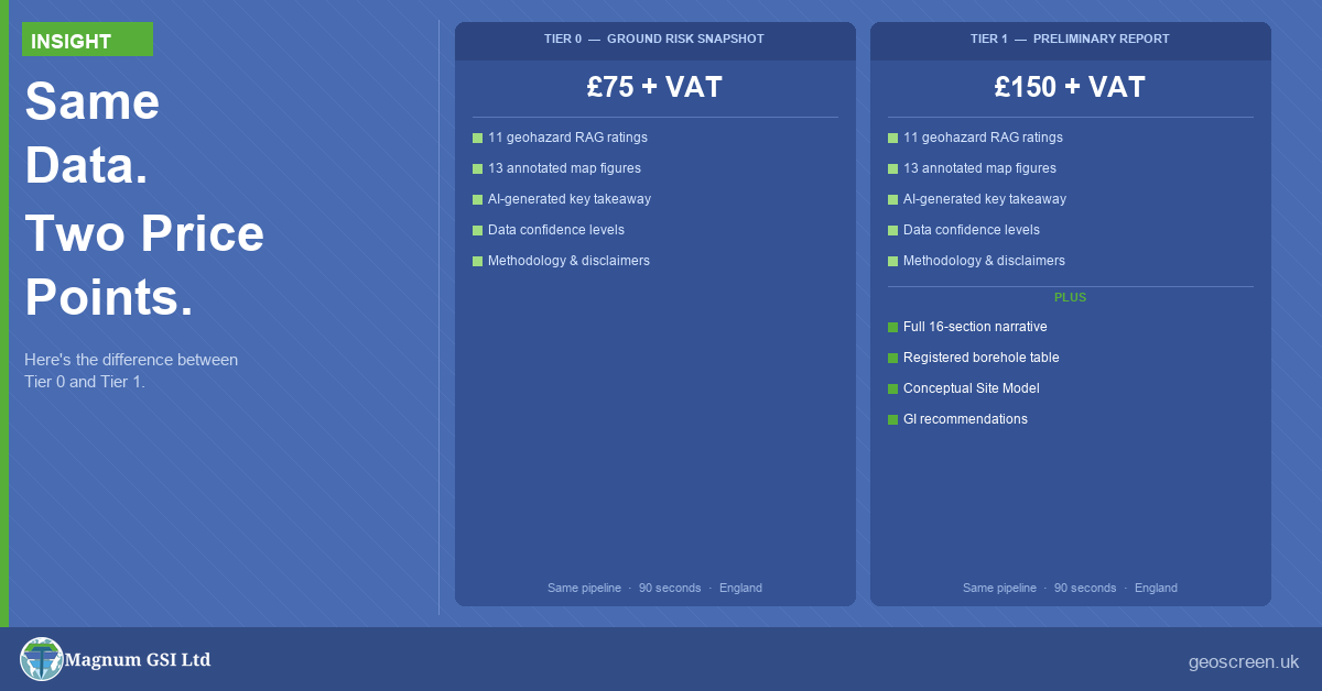
- Tier 0 — Ground Risk Snapshot: £75 + VAT
- Tier 1 — Preliminary Ground Risk Screening Report: £150 + VAT
The question we’re getting is obvious: what’s the difference?
The short answer is simple: the data is identical — only the output changes.
What doesn’t change
Both Tier 0 (T0) and Tier 1 (T1) run the same underlying process:
- The same 11+ data sources
- The same 11 geohazard categories
- The same RAG rating engine
- The same 13 annotated map figures
- The same QA checks before delivery
Every dataset, every API call, and every rating is identical.
T0 is not a simplified version of T1. It is T1 without the narrative layer.
If you start with T0 and later move to T1 for the same site, the RAG ratings won’t change — only the level of explanation.
Tier 0 — Ground Risk Snapshot (£75 + VAT)
T0 is built for speed, clarity, and portfolio-scale screening. It gives you the outputs you need to make an informed decision — without paying for detail you may not need yet.
You get:
- Cover page with site details and overall RAG rating
- Geohazard summary table — all 11 hazards rated Low / Medium / High / Very High, with confidence
- A concise key takeaway (2–3 sentences) highlighting principal risk drivers and any material constraints
- All 13 annotated map figures (Appendices A–M): geology, superficial deposits, flood risk, mining, radon, heritage, ecology, surface water flood, historical mapping (three epochs), and source protection zones
- Methodology and limitations
Where T0 fits:
- Screening multiple sites before shortlisting
- Rapid feasibility checks prior to instructing further work
- Experienced users who can interpret RAG ratings and figures directly
It’s designed to be read and understood in minutes, not reviewed as a formal report.
Tier 1 — Preliminary Ground Risk Screening Report (£150 + VAT)
T1 is the full structured product. It uses the same data, ratings, and figures as T0 — but adds a complete, structured narrative across the report.
You get everything in T0, plus:
- Full executive summary with key risks, next steps, and cross-references
- Site setting, planning context, and site history
- Geology, hydrogeology, and flood risk interpretation
- Individual narrative for each of the 11 geohazard categories, including data sources, risk drivers, and recommended next steps where appropriate
- Qualitative foundation assessment
- Borehole table (BGS SOBI records within 1 km, where available)
- Conceptual Site Model (CSM): sources, pathways, receptors
- Conclusions and recommendations
- Section 12 limitations and disclaimer
T1 is designed to be shared and relied upon, whether with clients, planning consultants, lenders, or project teams.
It is a Preliminary Ground Risk Screening Report, prepared with reference to the principles of BS 5930:2015+A1:2020, with a full audit trail and canonical version control.
The real difference
The distinction isn’t in the engineering. It’s in the delivery format.
T0 gives you the answer.
T1 explains the answer.
Both are based on the same underlying assessment. The only question is how much of that assessment needs to be written out.
How to choose
Choose T0 if:
- You’re screening multiple sites at feasibility stage
- You need fast, consistent comparisons across a portfolio
- You want the RAG ratings and figures before committing further
- You’re comfortable interpreting outputs without narrative
Choose T1 if:
- You need a document you can formally share
- The site presents High or Very High risks
- You want context behind the ratings
- You’re preparing for planning or early-stage reporting
- You want a structured foundation for further investigation
If you’re unsure, T0 is a sensible starting point. The RAG table and key takeaway will quickly tell you whether a site justifies deeper review.
What we’re working on next
GeoScreen is continuing to evolve, with a focus on strengthening the value delivered across all tiers without compromising speed or simplicity.
Current areas of development include:
- Incorporation of DTM (LiDAR-derived terrain modelling) to enhance topographic context and support interpretation of ground conditions
- Integration of Environment Agency EPR (Environmental Permitting Regulations) data, capturing permitted industrial, waste, and water activities that may influence site risk and planning considerations
These enhancements are aimed at improving early-stage screening while maintaining rapid turnaround.
Both are live
Both tiers are now available at GeoScreen.
- England only (MVP)
- Reports delivered by email
- Typically generated in around 90 seconds
£75 + VAT (T0) · £150 + VAT (T1)
Same data. Same figures. Same RAG ratings. The only difference is how much narrative you need.
Tristan Morgan
BSc(Hons) EurGeol CGeol FGS AMICE
UK Registered Ground Engineering Specialist
Director, Magnum GSI Ltd